

About the Bay
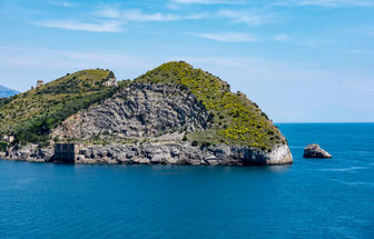
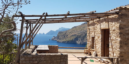
Located in Massa Lubrense in the Marine Protected Area of Punta Campanella is the Bay of Ieranto. The bay spans over 1,500 hectares of sea between Naples and Salerno and a little over 30 km of coastline. It is home to views of the island of Capri, limestone cliffs, rich biodiversity, clear waters perfect for swimming, hiking paths, and numerous caves. Today it is a natural protected area on both the sea and the land. The landscape and agriculture, with olive tree terraces, citrus fruits and local vegetables; the Mediterranean Vegetation scattering the lands and the various shades of blue in the sea make this place a natural paradise.
The bay is protected on the land by the FAI, the Italian Environmental Fund, which is a non-profit foundation aiming at protecting Italy’s historical, artistic and landscape heritage. Ieranto Bay has much history to it, having been used by many civilizations throughout history, with evidence of ancient Greeks and Romans in the area, and more recently it being used as a limestone quarry until the 1950s. The bay is protected on the land by restricting what people who come are allowed to do: you are not allowed to pick any of the plants such as flowers, fruits, and vegetables and are not allowed to take fossils. You are also not allowed to camp or light fires.
The bay is protected on the sea by the Marine Protected Area of Punta Campanella by restricting access of motor boats as well as other activities such as fishing. While motor boats are not allowed in the bay due to its protection, you can kayak into the bay! The underwater world of Ieranto Bay is rich in species and habitat biodiversity. Several types of fish, molluscs, crustaceans and invertebrates thrive in the bay, moving between the rocky cliffs, seagrass meadows and underwater caves of the bay in a very pristine environment.

How to join the site by the land
To get to Ieranto Bay by walking, you first have to go to Nerano, which is accessible by the SITA bus or car from many of the surrounding towns. Getting dropped off at this fishing village at the tip of the Sorrentine Peninsula, you will start on the hiking path to Ieranto Bay. This accessible path is about 50 minutes long, taking you past breathtaking cliffside views and an assortment of mediterranean vegetation. In total, it will take 2.5 km with a total altitude chance of 250 meters. The route you take is shown below in yellow, taking you from Nerano to the Bay of Ieranto.
How to join the site by the sea
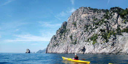
To reach Ieranto Bay by kayak on a path accessible for beginners, you have to start at Marina del Cantone. Starting here, you make the trek to Ieranto Bay, enjoying views of the sea to your left, and cliffs to your right, housing a plethora of birds to watch as you paddle past.
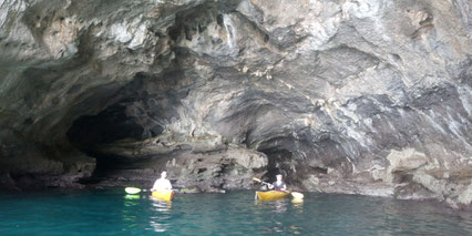
Continuing a little past Ieranto Bay and going around the bend of rocks to the smaller bay, you can pop into a few caves housing multiple habits and species! The first cave you can enter has little sunlight and rougher waters, but a nice sight to see with icy blue waters inside!
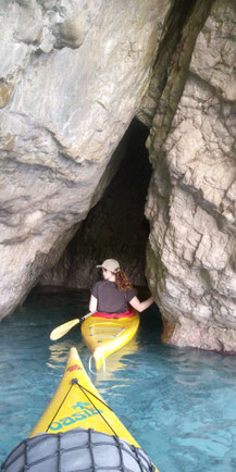
Going further along this path, you can enter another cave, where different access to sunlight in the caves allows for numerous habitats. Abundant red algae grows where the sunlight shines and animals that usually are found in much deeper and darker waters can be found much closer to the surface in the darker areas of the cave, making it a unique place for diving and snorkeling! A kayak can take you in one entry of this cave, while swimming can take you out the other, much smaller way.
Going out of the cave, you can then swing around to see the Bay of Ieranto and enjoy the gorgeous waters, crystal clear due to their protection!
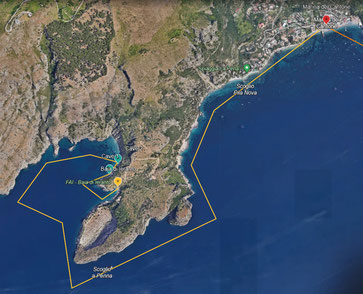
This route is detailed out in the map below, with the starting point of Marina del Cantone and the end point of Ieranto Bay.
History
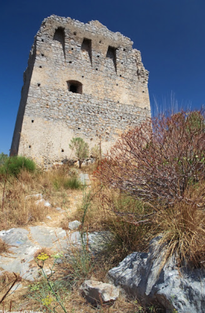
As mentioned above, the area has been used by many civilizations. Villages in the area date back all the way to the Bronze age. The Greeks used this area to build a temple to the goddess Athena for the protection of sailors, Italics occupied the region for a time, Romans came and built villas, and incursions from the sea occurred all too often that the Normans built numerous watchtowers here to be able to spot Saracen pirates from the sea from far away.
From the beginning of the 1900s until the 1950s, the area was used as a limestone quarry operated and owned by Ilva steel corporation. Evidence of this still exists in the rockface that has parts taken out of it and the buildings set up for the workers. Recently, the history and the beauty has drawn many in, with romantics in the nineteenth century calling to preserve the land, which is attributed as the gorgeous birthplace of Homer’s Sirens. After the limestone quarry’s closure in the 1950s, the owner donated the area to the FAI, who then opened the bay to the public in 2002, for all to enjoy.
Vegetation
The vegetation of the area is very diverse, with Mediterranean Maquis prevalent such as holm oaks, broom, myrtle, and olive trees as well other vegetation such as chestnuts, turkey oats, alder, and citrus trees. The biodiversity in the water is also spectacular with over 260 species found here in the nutrient rich water resulting from the process of upwelling that brings cold nutrient rich water to the bay. Posidonia meadows are common in the water here which house huge amounts of biodiversity such as fish, shrimps, and seahorse.